Abstract
The research area is located in the Debub Omo Zone of the Southern National Regional State, within Dimeka woreda. It can be reached via a 720km road from Addis Ababa passing through Welayita Sodo, Arbaminch, Konso, and Turmi. The main objective is to delineate the marble resources and determine their industrial applications based on quality. Geological, geochemical, and physical tests revealed the presence of marble, granite, quartz, feldspar, base metals, various types of gneiss, basalts, mafic and ultramafic rocks, and alluvial sediments. The gneiss terrain is intersected by dikes and veins, and basalt layers contain gemstones such as agate. Marble occurs in white, gray, and dark colors, depending on impurities, with geochemical analysis showing CaO content between 26.68 and 35.16 wt% and MgO between 14.18 and 20.8 wt%, identifying the marble as dolomitic in origin. The marble is suitable for diverse industrial uses including dimension stone, fillers, and coloring agents in paper, cosmetics, plastics, and putty, as well as for acid neutralization in aquatic and soil environments. It also serves as an inert filler in pharmaceuticals, materials for sculptures and ornaments, calcium additives for animal feeds, and decorative building materials like floor tiles and window sills. Chemical and physical analyses confirm its suitability with some beneficiation. Approximately 8.71 million tons of indicated marble resources are estimated by section logging and profile descriptions; however, the total reserve is expected to be higher due to unassessed deposits and difficult access. Overall, the dolomitic marble deposit from dolomite origin has properties that support its application across various industries.
|
Published in
|
Science Frontiers (Volume 7, Issue 1)
|
|
DOI
|
10.11648/j.sf.20260701.12
|
|
Page(s)
|
17-31 |
|
Creative Commons
|

This is an Open Access article, distributed under the terms of the Creative Commons Attribution 4.0 International License (http://creativecommons.org/licenses/by/4.0/), which permits unrestricted use, distribution and reproduction in any medium or format, provided the original work is properly cited.
|
|
Copyright
|
Copyright © The Author(s), 2026. Published by Science Publishing Group
|
Keywords
Genesis, Tectonic, Metamorphic, Alluvial, Ultramafic
1. Introduction
Metamorphic and sedimentary succession rocks are exposed in the preferable parts of Ethiopia. The sedimentary rock deposits within tectonically formed basin were the primary cause for the resource of most industrial minerals. The crystalline basement rocks are the product of those sedimentary as well as associated igneous rock combinations due to metamorphic process. The crystalline basement rocks of Ethiopia are exposed in northern, western, southern and south western parts of the country. Numbers of research were done on those crystalline basement rocks. The United Nation program in 1967 and 1971 were studied on metallic and associated industrial mineral potentials of southern (Sidamo) and south western (Wollega) crystalline basements rocks. The southern and western parts of Ethiopia are relatively rich by those industrial rock resources due to African orogeny of Mozambique belt association. The Omo River basins sedimentary and crystalline basements are located in the southwest of Ethiopia that bound by Kenya and South Sudan
| [1] | Davidson A., 1983. Reconnaissance Geology and Geochemistry of Parts of Ilubabor. |
| [12] | United Nation program. 1967 and 1971. The Southern (Sidamo) and south western (Wollega) crystalline basements of Ethiopia are studied for metallic and associated industrial mineral potentials. |
[1, 12]
. The Omo River basin and high-grade metamorphic terrain consist of varieties of industrial minerals. The Omo basin is the main target area for oil and gas exploration for many decades but now it is targeted area for exploration and evaluation of industrial minerals especially marble resource. Beside that the area is promising for exploration of granite, base metals and other gemstones. Because there are a number of pre and post tectonic granite and other mafic ultramafic intrusive rocks in the area. The area is described by the dominant formations of siliclastic metasedimentary, quartzo feldespatic, and associated mafic ultramafic metamorphic rock varieties. It is part of the Omo River basin and southern Mozambique belt high grade metamorphic terrain. The current extreme industrial resource demand and limited supply take attentions to explore marble in the south Omo River basin. The marble resource is one of the most important industrial minerals can be applicable for different industries. The current study of this resource Is typical solution for the scarcity of marble in building, kitchen cabinets, boarding and other industrial purpose
| [2] | Melesse M. and Demerew Y., 2003. Report on the Geology, Geochemistry and Geophysics of Konso area, Southwestern Ethiopia, p. 17-40. |
| [13] | Walle, H., Zewude, S. 2000. Geological Report on Bulen Marble, Geological Survey of Ethiopia, (unpublished). |
[2, 13]
.
1.1. Location and Accessibility
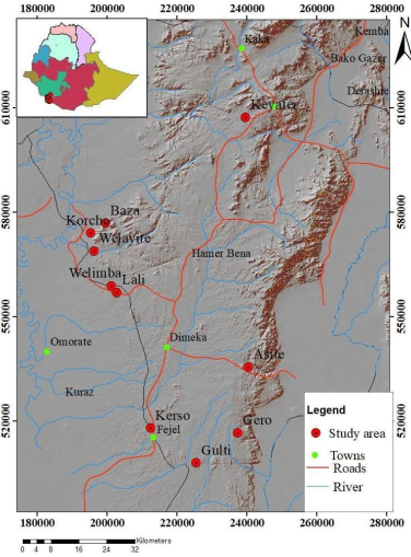
The study area is located in Dimeka Woreda, Debub Omo Zone, within the Southern Nations, Nationalities, and Peoples' Regional State of southwestern Ethiopia. It is accessible via a 720km road from Addis Ababa, passing through Welayita Sodo, Arbaminch, Konso, and Turmi. Of this distance, 630km from Addis Ababa to Keyafer is paved with asphalt, while the remaining 90km to Turmi town is on a weathered gravel road. The targeted site lies approximately 200km from the Dimeka camp.
Figure 1. Location and accessibility map of the area.
1.2. Physiography and Drainage of the Study Area
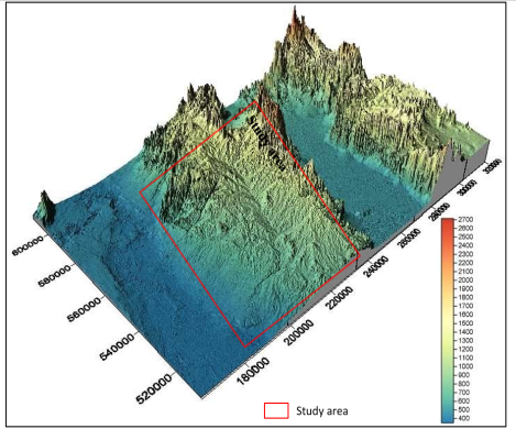
The physiographic features of Omo basin was characterized by irregular fashions that is caused by tectonic activities, river cuts and volcanic activities. There are two common drainage divides within the map area these are Lake Turkana and Chew Bahir drainage system (see
Figure 1). Physiographic conditions of the area and its surroundings are described by flat alluvial sediments and high relief folded ridges and associated intrusions. The higher topographic landscapes of the areas are typical features of metamorphosed and deformed mountains with associated plutons. There are a number of posts and pretectonic intrusive rocks that form ridge and hill topography. Valleys and recent sediments were show low morphology of the area
.
Figure 2. Physiographic map of the study area and surroundings.
2. Methodology
The objectives of the study accomplished using various technical methods and approaches. This project begins with a desk study and progresses to hands-on field observations. The fieldwork is supported by preparatory and follow-up tasks conducted in the office, while the core activity involves direct observation on site. The primary methodologies used include:
2.1. Geological Mapping and Field Work
Geological mapping and field work is the main techniques applied for this field project. The study area is mapped for marble resource delineation through field observation and mapping by 1:10000 scales. Field work is crucial methodology in this project for collecting samples of marble minerals and surrounding rock variations. The general strike orientation (attitude) of country rock, lithological variation, geological structures, and mineralization as well as alteration zones of the area are identified by geological field work. Mapping and delineating of each lithology units, measuring the different geological structures and taking various cheap sampling were taken. In order to complete the field work and achieve its main goal gully and river section logging were conducted. Those field practical works are applied mainly depending on complexity and clarity of the geology. It is very important techniques of approaches to understand the vertical sections (thickness) and lateral continuity of marble resource in the area.
2.2. Geochemical Analysis
Geochemical analysis is important methodology for this field project work. It is useful to chemical properties of the rocks and marble mineralization. Major element, trace element and some other element analysis are conducted to know the marble quality and field of application. A total of 90 marble, granite and mafic and ultramafic rocks have been collected for further geochemical and physical analysis. The selected samples were powdered based on the laboratory specifications.
2.3. Satellite Image Analysis and Interpretations
The remote sensing data and images were the most important tools for identify lithological variations and mineralized zones. Land sat images were analyzed and interpreted during the field work and pre field activities. This methodology is used to easily differentiate the felsic and mafic ultramafic rock compositions in the area. Therefore, using applications of remote sensing is helpful to explore marble within the crystalline basement rock of the area.
2.4. Map Preparation and Data Interpretation and Report Writing
Once the field geological and laboratory analysis were done the next step is compiling and interpretation of those data using different software. Geological mapping of each five sites were carried out at scale of 1:10,000. The geochemical and physical results of marble and other samples were interpreted and compared with other standards. The compiled results of the above data were presented as well-organized field report.
2.5. Weather and Climate Conditions
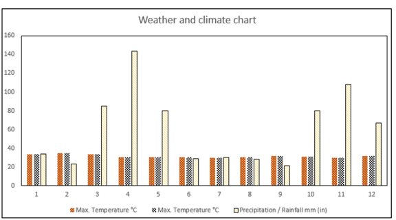
The weathering condition of the area is classified as desert and it has very worm atmosphere. The southern Omo area is known by its hot and very drying condition which obtains rainy season of in a month of June. The area is mainly characterized by very low infiltration rate and high drying conditions. The region has very low elevation and it seasonally gets little rainfall in June. At an average temperature of 29.1°C | 84.5 °F, February is the hottest month of the year. In November, the average temperature is 25.4°C | 77.7 °F. It is the lowest average temperature of the whole year. Around 3619.45 hours of sunshine are counted in 6 Hamer Village throughout the year. February is the highest number of daily hours of sunshine (10.48 hours of sunshine a day) is measured in Hamer Village on average. Whereas, January is the lowest number of daily hours of sunshine (9.38 hours of sunshine per day). The month with the highest relative humidity is April (63.45%) and the west humidity is in February (31.92%). Precipitation is the lowest in September, with an average of 21 mm | 0.8 inch. Most precipitation falls in April, with an average of 144 mm | 5.7 inch.
Figure 3. Weather and climate conditions of the area.
2.6. Regional Geology
The regional geology of the southern and south western Ethiopia was studied in detail by different scientists and investors. Southern Ethiopia including Konso and its surroundings are geologically characterized by high grade metamorphism, pre and plutonic intrusions and recent alluvial sediments to tertiary volcanic. Quaternary sediments were parts of the regional geology. The lithological studies were regionally mapped by a scale of 1:25000. The regional map was done by the Omo River Project work. The southern Ethiopian intrusive and granitic varieties are typical characteristics of post tectonic formations shows the Pan African Mozambique belt evolution
| [18] | Omo River Project Team. (Year not stated). Regional geologic mapping at 1:25,000 scale covering southern Ethiopia: Compilation and interpretation of regional lithologies and structural features. Ethiopian Geoscience Series, 5, 102-128. |
[18]
. The project work shows results of base metals copper, Zinc cobalt, Nickel and kaolin. The geology and structural studies were done by the Ethio-Canadian project regionally. The dominant lithologies were mapped by this project work. The Hamer and surrounding areas were geologically dominated by undifferentiated sediments, lat- syn tectonic granite, and granodiorite with granitoid gneiss, metasedimentary gneisses and granulite facies
| [16] | Ethio-Canadian Project. (1972–1974). Geological and structural studies of southern Ethiopia: Regional lithologies, basement characterization, and base metals potential (Cu, Zn, Co, Ni) and kaolin. Final project report, Ethiopian Ministry of Mines (unpublished internal report). |
[16]
. The metamorphic complex and associated intrusive are make up the southern Ethiopian geology which is characterized the Mozambique belt and Pan African Orogenic formation sediments were under erosion. The crystalline basement rocks and associated volcanic with sediments are the main varieties that exposed in the area
| [17] | Davison, R. (1983). The crystalline basement and associated volcanic-sedimentary sequences in southwestern Ethiopia: Mapping and petrological implications. Geological Survey of Ethiopia Bulletin, 9, 77-98. |
[17]
. The major regional geologic rock types of the area and surroundings are metasedimentary gneiss, alluvial to fluvial lacustrine sediments, layered mafic gneiss and amphibolite and undivided gneiss–migmatite as well as other undifferentiated sediments. The regional geologic map of the area and its surrounding are illustrated by regional map of the area low. The crystalline basement of southwestern Ethiopia belongs to the lower complex, which comprises various gneisses. The geology is divided in to four units in this area based on age,
| [17] | Davison, R. (1983). The crystalline basement and associated volcanic-sedimentary sequences in southwestern Ethiopia: Mapping and petrological implications. Geological Survey of Ethiopia Bulletin, 9, 77-98. |
[17]
. These are the crystalline basement (Precambrian to early palazoic), 10 terrestrial sediments (Permian), pre rift volcanic rocks (Eocene to Miocene) and post rift deposits (late miocen to holocen). The crystalline basement rocks are exposed in ilubabur, southwestern of kefa, southwestern of gamogofa and southwest of sidamo. these are divided in to three, namely the hammar domain, the akobo domain and the surma domain. The hammar domain contains a compex of older gneiss and granulite that are highiy deformed and crystallized and in part migmatized with a suit of younger plutonic rocks that are much less to not at all deforemed and recrystallized
| [2] | Melesse M. and Demerew Y., 2003. Report on the Geology, Geochemistry and Geophysics of Konso area, Southwestern Ethiopia, p. 17-40. |
[2]
. There are different type’s gneisses in the area. Five major lithologies were found adequate to express the main differences among the gneisses of the older complex. These are: a) mafic gneiss and amphibolites, which, is relatively dark gneiss, usually rich in hornblende and poor in or lacking quartz it occupies several strips in the hammar range and western hamar plains, particularly closest to lake turkana
| [3] | Kazmine, V., 1972. Geology of Ethiopia, Explanatory notes to Geological Map of Ethiopia 1:2,000,000, Ethiopian Institute of Geological Surveys. |
[3]
. Amphibolites and less mafic hornblend gneiss are interlayer in various ratios and at different scale with in most of this unit. In other areas notably just north west of chew bahir due north of minogelti and southwest of turmi. Relatively uniform masses of dark hornblend gneiss likely present deformed and metamorphosed gabbroic to quartz dioritic plutonic rocks. General compositional considerations, however, suggests that a package of mafic to intermidate volcanic rocks with in minor sedimentary component and containing relatively mafic intrusive forms the most likely progenitor of this unit. b) meta sedimentary gneiss and granulite, which is prominent in the hamar range and western hamar plains, particularly in the southern part. They are traceable mainly on account of thier well layered character and the presenence of rusty zones. This distinictive type of gneiss provide marker horizons that help to outline the regional structure. one particular notable marker is alayer of blue-white graphite breaing dolomite marble in the southern hamar range tha can be traced continiously for at least 20km even though it is only avery few tens of meters thick. As noted the transition to granulite facies is accompanied by darknig of the feldespars; plagioclase aquires an olivin green color, k-feldspare golden brown 11 meta sedimentary granulites in the hamar region are characterized by thick red brown weathering rinds (
| [4] | Davidson A., et al., 1973. Omo River project Preliminary Report NO. 1, P. 20-22. |
[4]
. c) Biotite and hornblend gneiss, much of this unit is relatively uniform and poorly layered orthogneiss representing deformed and metmorophosed plutonic rocks of dioritic quartz, dioritic and tonalitic composition relict primary texture is rarely preserved. Biotite hornblend or both of these minerals are the dominant mafic mineral in this unit, garnet epidot and augite are present in small amounts locally in the hamar region the grey gneiss attain granulite facies and are darker greenish grey in color were fresh and distinctively more granular in texture Davison (1983) d) muscovite-biotite granitoid gneiss, muscovite bearing gneiss are not widespread in the hamar domain owning to the presence of high grade metamorphic conditions under which muscovite is not stable in the presence of quartz Davion etal,(1973). The gneiss of these occurences have a granitoid aspect. They are generally light grey to pinkish grey well foliated due to alignment of micas and relatively homogeneous in composition with only poor development layering in places. The proportion of the muscovite and biotite varies and muscovite is not everywhere present. In some places muscovite occurs as coarse aggregates probably of secondary origin. e) quartzo feldspatic gneiss, It underlies large tracts of ground between jinka and the north end of the hamar range, between beto and northern part of chew bahir rift. Rocks of this unit vary from being relatively uniform orthogneiss to well layered gneiss, and probably contain rocks of both plutonic and supracrustal origin. They are characterized by their light grey, pink, buff or cream colors and by low clor indices. the south western most quartzo feldspathic gneisses are associated with metasedimentary gneiss and contain local varities relativly rich in quartz, suggesting that the may once have been feldspatic sandstone
| [15] | Davidson, A. (1983). The metamorphic complex and associated intrusive of southern Ethiopia: Implications for crustal evolution and erosion history. Ethiopian Journal of Geosciences, 12(1), 23-41. |
[15]
. In addition to gneiss complex younger plutonic rocks are present in the area these rocks are considered to be younger than any of the previously described gnessic rock units occur as discret bodies in cluster within the hamar domian. The range is widely in composition and in site of preservation but are all characterized by lack of gneissic (tectonic) layering and by 12 retentions of primary igneous texture and mineralogy. All granitoid is found west of kei afer and around jinka. Gabro and ultramafic rocks, it found within mafic gneiss and granulites to the west-northwest of konso. In granulite facies the mafic rocks contain haypersthene aswell as augite and garnet occurs with both pyroxenes in the konso region more sparingly in the central parts of the hamer granulite zone. Syn tectonic granite considerable variety exists among the granite plutons in the hamar domain. Those units have somewhat irregular contacts, concordant in detail with layering in adjacent rocks, and locally interfingering with them. Internally they are generally uniform but rarely massive. the greatest concentration of granite dyke some more than 20m wide occurs in the region of south of Turmi. Late-and post tectonic granite are composed of non-deformed granitoid rocks. The Konso region have particularly sharp, cleanly cross cutting contacts and may be younger than the others granitic rocks and late pegmatite in the other part of Ethiopia and yield age by both k-ar and rb-sr methods ranging from 700 to 500ma, that is spanning the late Precambrian -Paleozoic time boundary
| [3] | Kazmine, V., 1972. Geology of Ethiopia, Explanatory notes to Geological Map of Ethiopia 1:2,000,000, Ethiopian Institute of Geological Surveys. |
| [5] | Amenti A., 1996. The Precambrian of Southern Ethiopia. EIGS, Addis Ababa. |
[3, 5]
. Thus, it is feasible that the youngest plutons were intruded very early in the Paleozoic time. Remarkably few basalts and rhyolite dyke related to the overlaying Cenozoic volcanic rocks were observed within the gneiss complex. They are described in subsequent section on the hypabyssal intrusions
| [17] | Davison, R. (1983). The crystalline basement and associated volcanic-sedimentary sequences in southwestern Ethiopia: Mapping and petrological implications. Geological Survey of Ethiopia Bulletin, 9, 77-98. |
[17]
.
2.7. Geological Setting
A sedimentary basin represents a unit of geological structures which are received by sedimentary succession during a given span of time. Generally, basins are a depression area in the Earth's crust, of tectonic origin, in which sediments accumulate. Those sedimentary basins are formed by tectonical activities and later on it is accumulated by sediments. The southern rift basin is one of the five sedimentary basins and located in southern Ethiopia it includes; the Omo basin, the lake chew Bahir basin, and is the continuation of Turkana graben in north Kenya which was developed during the paleogin. The Omo and Chew Bahir basins lie within the broadly rifted zone of the southern Ethiopia bordering northern Kenya. Both are extensional basins bounded by N-S striking faults which 14 are assumed to be younger features that cross-cut older NE and NW striking faults of the area. The northern part of the Omo and Chew Bahir basins are presumed to be northward continuation of the Oligocene rift system of north Kenya
| [6] | Danilo A. J., 1966. About the geology of southwestern Ethiopia and Mineral occurrences of Ethiopia Ministry of Mines, Addis Ababa. |
| [20] | Alula Demete 1998 Ethiopia sedimentary basins” or “Omo–Chew Bahir basins Alula Demete 1998” and filter for journal articles or conference. |
[6, 20]
. The metamorphic complex with its attendant plutonic rocks that makes up the crystalline basement of Ethiopia is part of the Mozambique Belt, itself part of the Pan-African Orogenic System of late Precambrian to earliest Paleozoic age. Scattered small remnants of terrestrial sedimentary rocks, some known to be of Permian age, attest to a former wider cover in late Paleozoic time. These sediments were in part eroded before marine incursion from the east and northeast, beginning in late Triassic and continuing into Jurassic time. Resulting sedimentary rocks covered eastern and much of central Ethiopia
| [17] | Davison, R. (1983). The crystalline basement and associated volcanic-sedimentary sequences in southwestern Ethiopia: Mapping and petrological implications. Geological Survey of Ethiopia Bulletin, 9, 77-98. |
[17]
.
2.8. Granitic Gneiss
This rock unit is widespread in the study area mainly at Gembi (lalli) area. It is characterized by an alternately light and dark stratified structure. It is light gray in the weathered color and whitish to light pink color of the fresh out croup; it is medium to coarse grained with flaky mineral like biotite. Thus, the mineral composition of granitic gneiss is chemically similar to granite. From the representative samples of this unit, it is mainly composed of K-feldspar, quartz, plagioclase and biotite, muscovite minerals. K-feldspar is a major constituent in the rock and characterized by light pink color. It is formed from deformed and metamorphosed pre tectonic granitic plutonic rocks. It is systematically fractured and frequently jointed granitic photolith gneiss exposed along the river cut of the area. Beside the granitic gneiss meta granite is exposed in different parts of the area especially at the gambi kebele locality. It is found as ridge form exposure within amphibolite gneiss. It is composed of quartz, plagioclase, k- feldspar, muscovite and biotite. It is medium to coarse grain in texture and gray in color. The meta granite might have been emplaced during or pre deformations since it is slightly deformed or metamorphosed.
Figure 5. Field exposures of granite gneiss.
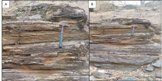
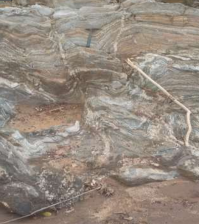
2.9. Meta Sedimentary Gneiss
The southern Ethiopian basement rocks are characterized by high grade gneiss and predominantly originated from crustal sediments and plutonic intrusions. The metasedimentary gneisses are typical of sedimentary origin and highly deformed rocks. The tectonic deformation of those rocks governs general orientation to N-S striking with little deviations to the N-W to E directions. These rock units are the main rocks that are host the marble mineralization in the area. Compositionally the meta-sedimentary gneisses are varying from felsic to mafic with preferred horizontal layering (
Figure 6). It is highly foliated and has well developed bandings of felsic and mafic alternatives. These rock units are extremely metamorphosed and tectonically deformed as well as affected by plutons (
Figure 6). Generally, these rocks are characterized by stratified to tilted layered beds. The meta sedimentary rock of the area is mainly interlayered by amphiboles-biotite and quartzo felspathic gneiss. The metasedimentary rock is exposed at Kara korcho area is composed of quartz, feldspar and mica and light in color. They are traceable mainly on account of their well layered character as shown in the (
Figure 6 A and B) below. Compositional layering in this unit is generally very well developed and expected that the original rock is sedimentary such as sandstone. Deformation and metamorphism have been so intense that most evidence of former sedimentary structures has been destroyed. It contains a rusty weathered zones and dolomite marbles
| [8] | Gilboy, C. F., 1970. The geology of the Gariboro region of southern Ethiopia. |
| [9] | Heldal, T., Walle, H. & Zewude, S., 1997. Natural Stone in Ethiopia Visited in 1996/97. |
| [14] | Asrat, A., & Barbey, P. (2003). Geological and geochemical evidence for post-tectonic intrusions in southern Ethiopian granitoids: Implications for the Mozambique Belt evolution. Journal of African Earth Sciences, 37(2), 145-161. |
[8, 9, 14]
.
Figure 6. Horizontally bedded gneiss.
3. Graphite
Thin layers of graphite are found in different parts of the area. This lithologic unit is mainly associated with meta sedimentary units. Thin layers of it found at Kizo, minwegelity and Kra korcho areas. But it is mixed with quartzite and sericite. Some places of the area weathered and mylonatized and altered.
3.1. Ultramafic Rocks
There are numbers of mafic and ultra-mafic rocks were exposed in different parts of the area. Around 5-6 meter wide and up to 300 length mafic rock with N-S orientation is found at Gambi lala locality. The trace element analysis result of it shows up to 420 wt% Ni. Beside that there are other exposures of it in different parts of the study areas. It is compositionally dominated by hornblende, olivine, pyroxenes and plagioclase. Generally, in most places these rocks show N-S orientation which is the orientation of major structures of the area. Very fine-grained hornblende and ultramafic compositional rocks are common later coming within quartzo - felspathic gneiss. This mantle sourced rocks are exposed as a veins and dikes of the surrounding quartzo- felspathic gneiss. The mafic rock is mainly characterized by its layered amphibolite gneiss and lenses of plagioclase lath.
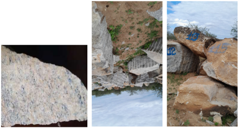
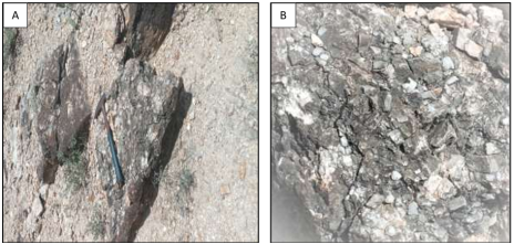
3.2. Granite
Granite is an igneous intrusive rock and one of the hardest and most dense types of rock. It is defined as a visible granular, igneous rock generally ranging in color from pink to dark grey and consisting mostly of quartz and feldspar accompanied by one or more dark minerals (ASTM C615). The granite intrusions of the study area are exposed to the west and north east direction of the Key Afer locality. The metamorphic rocks of Hammer Domain Mountain are affected by different types of pre tectonic and post tectonic intrusive rocks. An intrusion of the southern Ethiopia mainly comprises of granite rock and associated metamorphic varieties. The granitic intrusions of the region are tectonically affected, metamorphosed and contains late camer granites or post tectonic granite. Granite of the area form elongated ridge, hills and contains blocks of granite. Compositionally it is characterized as plagioclase, quartz and abundant 22 biotite and other mafic minerals. The granite rock which is located to west of Key Afer consists of syenitic, diorite and pyroxenes
| [1] | Davidson A., 1983. Reconnaissance Geology and Geochemistry of Parts of Ilubabor. |
| [7] | Davidson A. et al., 1975. Omo River project Preliminary Report No. 2, 10 pp. Kefa, Gemu Gofa and Sidamo, Ethiopia Bulletin no. 2, p. 19-30. |
| [10] | Kazmin V, 1975. The Precambrian of Ethiopia and some aspects of the geology of the Mozambique belt. Bulletin of geophysical observatory Addis Ababa. |
[1, 7, 10]
. These granitic intrusions are tectonically less affected and more massive in nature. Generally, this granite has little degree of deformation and foliations as it compared with the surrounding rocks. However, the granite exposure found in north east of Key Afer is strongly deformed and shows considerable foliations. Granite of the area is coarse to medium grained in texture. The granitic intrusion is morphologically massive and exposed as ridge and blocks of granitic are found on the surface of the Earth see (
Figure 7). Structurally it is characterized by frequently jointed to massive. The nature of granitic intrusions in the area is ranging from post tectonic to syn-tectonic. Post tectonic granite is exposed at the Gurmamele kebele, keyi afer woreda in the area. It is found as ridge topography. The description on rock samples using the hand lens indicates that K-feldspar (microcline), quartz, plagioclase, biotite, muscovite and plagioclase are the dominant minerals. The absence of metamorphism effect is observed on this lithology, since it is post tectonic and the country rock is biotite gneiss. It is very hard to break and generally whitish to light pinkish grey in color and medium to coarse grained in texture.
Figure 7. Massive granite blocks.
3.3. Basalts
This lithological unit is exposed at the Gelti locality in the southern Hamar. It is fine grained and Porphyritic in texture and has black fresh color and dark green to brown weather color. It is mainly composed of olivine, pyroxene, and plagioclase. This volcanic rock is exposed and overlaid on the lower basement rock of the area. The dominant volcanic rocks of Gelti area A B C D 25 are basalt but there are others like granite and ultramafic intrusions. It has sharp contact with the high grade metamorphic gneiss and layered mafic and quartzo-feldspatics of the area. Steep slope basalts were unconformable lied on the crystalline basement rock. Those volcanisms are separated from basements by variable thickness of alluvial sediments of the area. The cone shaped topography is typical characteristics of the volcanic rocks in the area. It is described as massive, columnar and blocks of basalt. Volcanic rock of the area is distributed within restricted area. This rock is the main construction industrial material in addition to the feldspatic gneiss and other rocks. It is fresh black color with some vesicles and most of the vesicles aren’t filled with other secondary minerals proved that it is quaternary in age.
Figure 8. Filed exposures of fresh aphinitic basalt cut by other veins and veinlets.
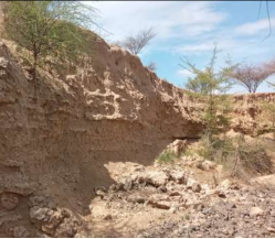
3.4. Alluvial Sediments
The Omo River basin is geologically characterized by thick and weathered continental crust products of alluvial sediment deposit. The sediments of the area are described as unconsolidated and friable dominated by silica sands deposited along the river channels. The sediments are compositionally felsic source and cover all river basins and streams of the area. This thick alluvial deposit sediments were underlying the crystalline basement rocks of the area. Simple surficially weathered, transported and redeposition are the possible mechanisms of sedimentation. Alluvial deposits are found in many parts of the study area especially the low land parts of the area. It is sandy soil dominated with brownish to reddish color clay soil. In some parts of the area, it is cross cutted by stream and clearly shown the section. Pebble to coble size of rounded to sub rounded gravels are found. The gravel aggregate are parts of the surrounding rocks such as gneiss, schist and other volcanic remains
| [11] | Mohr. 1960. Described the geology of the southern Ethiopian rift valley. |
| [18] | Omo River Project Team. (Year not stated). Regional geologic mapping at 1:25,000 scale covering southern Ethiopia: Compilation and interpretation of regional lithologies and structural features. Ethiopian Geoscience Series, 5, 102-128. |
[11, 18]
.
Figure 9. Horizontally bedded alluvial sediment.
3.5. Quartz and Pegmatite Veins
Quartz and other pegmatite veins are exposed in different parts of the area especially at wero and Gambela localities. Pegmatite veins are exposed in most parts of the study areas and occurred mostly within variety of gneiss lithological units and in small extent in other rock units. Besides that, felsic to intermediate intrusive rocks such as granite, dioritic to gabbroic units are found. The veins are composed of quartz, plagioclase, k- feldspar and mica group minerals. It is mostly rich in mineralization such as tourmaline and garnet, but mineralization is in disseminated form. It is very coarse grain in texture and light grey in fresh color. These pegmatite veins are up to 1-3 meters in width and 10-20 meters length are observed.
Figure 10. Quartz and pegmatite veins.
3.6. Calcite Veins
The calcite mineral is typically exposed at Kerso and in some extent at Gelti locality. Calcite is known for the variety and beautiful development of its crystalline structures and it is the principal constituent of limestone and marble. This calicitaization is precipitated within the fracture and fill the open spaces of county rock. The mineralization is long fracture filling that exposed as a rock form adjacent to the marble exposure and along the river cut. It is also formed by the replacement reaction process occurred near to the carbonate rock boundaries.
Figure 11. Exposures of calcite veins from Kersa locality.
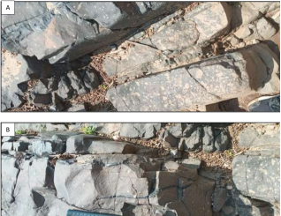
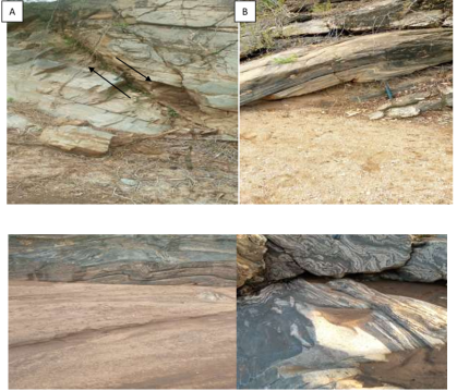
The area is subjected to different phases of deformations. The overall Structures observed in the area are complex, however both primary and secondary structures are well exposed. Folds, faults and joints are the common secondary structures were observed during field work. Those structures are common in the variety of gneisses. As shown in the figure below. A represents a normal fault which is the hanging well is sliding down on Meta sedimentary gneiss. This lithology is located at wolyte area and (
Figure 11A) and represents micro antifoam folds in the same lithology (
Figure 11B). There are also strike slip faults, like a 29 dextral or right lateral strike slip fault on basaltic dike. The general orientation of shearing is almost north-south but locally the orientation may be changed example at the Kerso locality the marble deposit is oriented at 305-degree NW. Foliation and shcistosity are the common primary structures of the area. They are formed during metamorphism and tectonic disturbance of the area. In many of gneissic rocks, mineral foliation makes a slight angle with layering.
Figure 12. Tectonic structures of the area.
4. Discussion
4.1. Discussion on Major Element Composition
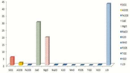
The major elements chemical analyses of 24 marble samples and 13 granite, feldspar and other mafic ultramafic rocks were done. The average chemical analyses of 24 marble samples indicate 5.6(SiO2), 30.07(CaO), 19.5(MgO), 1.76(Al2O3), 0.33(Fe2O3), 42.8(LOI) and minor other oxides. This indicates that the dolomite marble is high quality resource that can be used in various applications. The physical property tests also fall within acceptable limits set by industries. When compared with resources of other countries, the quality of the dolomite is comparable to similar resources used by various industries. The concentration of CaO has inversely relation with SiO2, Al2O3, K2O, Fe2O3, and MgO concentration, the concentration of those major elements are decreases with increase of CaO concentration.
Figure 13. Major element compositions of marble.
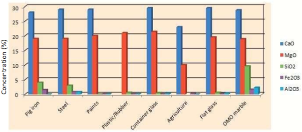
4.2. Discussion on Quality of Marble
The quality evaluation and resource calculation on the dolomite marble has been based on field and geochemical analytical results. The quality evaluations of marble were done after adequate surface, subsurface data collection and interpretation of it using different software. The marble deposit of the area has various types of color and incorporated with various remains of acidic and basic rocks. Only surface data cannot guaranty to evaluate this unit as resource for the production of dimension stone.
The major elements analysis results of Omo dolomite marble has been compared to raw material specifications (standard values) of dolomite rock used for direct application in various industries. As indicated below more than 74% of CaO fulfill for industrial applications, more than 65% MgO concentration fulfill the industrial application for pig iron, steel, flat glass and agriculture. The Fe
2O
3 concentrations of the current marble fulfill for all industrial applications mention below. The main drawback of the current marble is the presence of relatively higher concentrations of Al
2O
3 and SiO
2. Most industry needs less concentration of Al
2O
3 and SiO
2 but the concentration of those minerals are higher than the standard specification (
Figure 13). Beside the following table The USSR standard specifications for Dolomite marble for glass industry include <34 (CaO), >18 (MgO), < 1 (Al
2O
3), < 0.4 (Fe
2O
3), <1.5 (SiO
2).
Figure 14. Major element comparison of Omo marble with other standards.
Table 1. Major Element specifications for different industrial application.
Types of applications | Major element compositions |
CaO | MgO | SiO2 | Fe2O3 | Al2O3 |
Pig iron | >28 | >19 | <4 | <1.5 | - |
Steel | >29 | >19 | <3 | <0.8 | <0.8 |
Paints | >29 | >20 | - | <0.1 | <0.1 |
Plastic/Rubber | | >21 | <0.6 | <0.1 | <0.1 |
Flat glass | >29.5 | >19.5 | <0.6 | <0.25 | <0.4 |
Container glass | >29.5 | >21.4 | <0.5 | <0.1 | <0.3 |
Agriculture | >23 | 10-15 | - | <0.3 | - |
OMO marble | 28.82348 | 18.90174 | 9.638261 | 1.62 | 2.375556 |
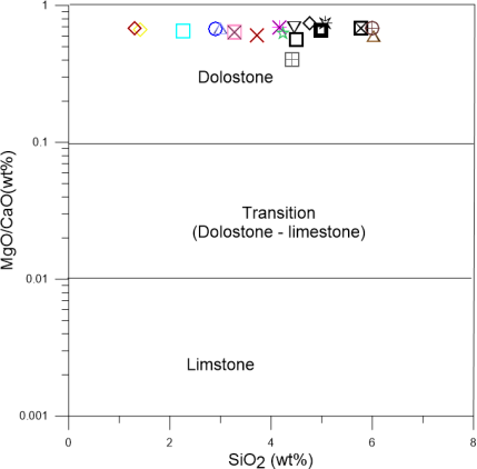
4.3. Discussion on the Origin of Marble
MgO, CaO and SiO
2 are the most common three minerals that are played a great role on the origin of marble. Marble comes from limestone, dolomite and intercalation of limestone and dolomite. Generally, it comes from any carbonate rocks. High concentration of MgO related to dolomitic origin while, high concentration of CaO and low concentration of MgO is related to limestone origin. From the MgO/CaO vs. SiO
2 diagram (
Figure 15) below all of the selected samples are failed within dolostone zone and it indicates that the origin of it is dolomite. The dolomitic rock were affected by metamorphism and changed to marble.
Figure 15. Binary diagram on the origin of marble.
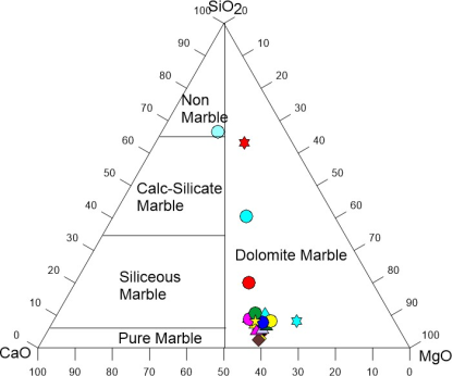
4.4. Types of Marble
Most marbles contain both dolomite and calcite, with calcite generally being the more abundant. Marble is non-foliated metamorphic rocks that can be converted from limestone, dolomite or an intercalation of limestone and dolomite. Generally, any carbonate rock subjected to pressure temperature or metamorphism it changes to marble. It is metamorphic crystalline rock composed predominantly of crystalline grains of calcite, dolomite or serpentine and other finny minerals. Generally, marble can be classified into two that is either calcite or dolomitic marble based on the composition. The color of marble various based on the presence of different impurities. The color of pure marble is whitish color that is dominated by calcite minerals. Marble has been found in many parts of the country related with the metamorphic rocks. Marble is formed predominantly of calcite (CaCO3), feldspar and quartz.
CaO, MgO, and SiO2 were found to be the major element oxides that play the most significant role in the formation mechanism of marble samples. CaO and MgO is the most common major element in carbonate deposit of metamorphic terrain. The very low MnO content in the studied samples may be attributed to the similarity in the ionic size of Mn2+ and Ca2+, as both ions may readily substitute for each other on a crystal lattice (Ephraim, 2012). According to Goldschmidt et al. (1955), the CaO contents in calcitic marbles are usually around 50–54 wt%, while MgO contents are <15 wt%. The average CaO content of the Omo marble ranges 26.68 – 35.16 wt.% with an average value of 30.07 wt% and A MgO content of 14.18-20.8 wt% with an average value of 19.5 which show dolomitic marble and the original rock is dolomite. The LOI content varies between 40.69 and 43.42 wt.% with an average of 42.43 wt.% the highest values likely reflecting rocks with the lowest quartz contents. Qadhi (2008) observed that the proportion of silicate minerals, Such as chlorite and quartz, in marble was negatively correlated with the LOI values of the rocks.
4.5. Depositional Environment
The depositional environments of the original protolith of the current marble were determined from the alkali content of it. The presence of high concentration of Na2O and K2O indicates deep environment, while, low concentration of those alkali elements are related with shallow environment. Because the alkali content of carbonate rock is decrease with an increase in salinity and depth. More than 60% of the samples has low concentration of Na2O + K2O <0.02 and marble with Na2O + K2O <0.1 is classified as shallow environment. Some of the samples has high concentration of Na2O + K2O and classified as deep environments. Davou and Ashano (2009) reported that low concentrations of Na2O in marble indicate a shallow, near-shore, low energy, and clean water marine environment of deposition for the protolith. A low Al2O3 concentration is also interpreted as indicating a low-energy environment.
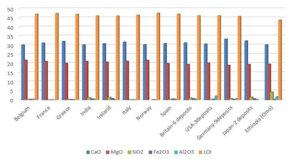
4.6. Comparison with Other National and International Deposits
The chemical and other physical properties of Omo marble is compared with other international marble deposit. Because those major element and physical properties of marble is play a great role on the industrial applications of it. Among those main constitute of major element value of the current the current marble is close to feat with other international deposit except the presence of relatively higher concentration of SiO
2 and Al
2O
3. The physical properties of marble are compared with other marble deposit of Ethiopia. The water absorption, porosity and bulk density of marble is Omo marble is good correlation with other deposit in Ethiopia see (
Figure 15A). As compared it with USA standard it has low value of porosity and bulk density. This indicates that it is highly compacted due to the presence of high degree of metamorphism
Figure 17. Comparison of marble with other international deposit.
5. Conclusions
Marble is widely used across various industries due to its versatility and aesthetic appeal, serving as a dimension stone, filler, coloring agent, and even in agricultural and pharmaceutical applications. However, it does have notable drawbacks: marble feels cold during winter, is susceptible to acid etching, and requires special care to maintain its appearance and integrity. Additionally, marble reacts with atmospheric gases and rainwater, leading to dissolution and degradation over time, which limits its durability in certain environments.
Geological investigations in the area reveal the presence of diverse rock types, including gneiss, felsic to mafic intrusives, alluvial sediments, and volcanic rocks. Among these, meta-sedimentary gneisses are the primary host for marble deposits. The physical and chemical properties of Omo marble indicate its suitability for multiple industrial uses, such as dimension stone, agriculture, pig iron, steel, and flat glass production. However, the marble contains relatively high concentrations of Al2O3 and SiO2, which can affect its quality and performance in some applications.
Marble is a non-foliated metamorphic rock formed from limestone or dolomite, and the MgO/CaO vs. SiO2 binary diagram confirms that the samples from this area originate from dolomite. Ternary diagrams of CaO, MgO, and SiO2 further show that all samples fall within the dolomitic marble range, indicating that the marble is predominantly dolomitic. Marble is used in dimension stone, as a filler and coloring agent in industries like paper, cosmetics, plastics, and putty, for acid neutralization, as an inert filler in pharmaceuticals, in sculptures and ornaments, as a calcium additive in animal feed, and for decorative elements such as floor tiles, stair treads, window sills, and panels. The physical properties of the marble, including porosity, water absorption, and bulk density, meet industry standards, and the estimated indicated marble resource is 8.71 million tons.
Abbreviations
ASTM | American Society for Testing and Materials |
Wt% | Weight Percent |
Author Contributions
Ewunetu Mitku: Conceptualization, Data curation, Formal Analysis, Funding acquisition, Investigation, Methodology, Validation, Visualization, Writing – original draft, Writing – review & editing
Mekdes Taye: Conceptualization, Data curation, Formal Analysis, Funding acquisition, Investigation, Project administration, Supervision, Writing – original draft, Writing – review & editing
Conflicts of Interest
The authors declare no conflict of interests.
Data Availability Statement
The data used in the study will be available upon request.
References
| [1] |
Davidson A., 1983. Reconnaissance Geology and Geochemistry of Parts of Ilubabor.
|
| [2] |
Melesse M. and Demerew Y., 2003. Report on the Geology, Geochemistry and Geophysics of Konso area, Southwestern Ethiopia, p. 17-40.
|
| [3] |
Kazmine, V., 1972. Geology of Ethiopia, Explanatory notes to Geological Map of Ethiopia 1:2,000,000, Ethiopian Institute of Geological Surveys.
|
| [4] |
Davidson A., et al., 1973. Omo River project Preliminary Report NO. 1, P. 20-22.
|
| [5] |
Amenti A., 1996. The Precambrian of Southern Ethiopia. EIGS, Addis Ababa.
|
| [6] |
Danilo A. J., 1966. About the geology of southwestern Ethiopia and Mineral occurrences of Ethiopia Ministry of Mines, Addis Ababa.
|
| [7] |
Davidson A. et al., 1975. Omo River project Preliminary Report No. 2, 10 pp. Kefa, Gemu Gofa and Sidamo, Ethiopia Bulletin no. 2, p. 19-30.
|
| [8] |
Gilboy, C. F., 1970. The geology of the Gariboro region of southern Ethiopia.
|
| [9] |
Heldal, T., Walle, H. & Zewude, S., 1997. Natural Stone in Ethiopia Visited in 1996/97.
|
| [10] |
Kazmin V, 1975. The Precambrian of Ethiopia and some aspects of the geology of the Mozambique belt. Bulletin of geophysical observatory Addis Ababa.
|
| [11] |
Mohr. 1960. Described the geology of the southern Ethiopian rift valley.
|
| [12] |
United Nation program. 1967 and 1971. The Southern (Sidamo) and south western (Wollega) crystalline basements of Ethiopia are studied for metallic and associated industrial mineral potentials.
|
| [13] |
Walle, H., Zewude, S. 2000. Geological Report on Bulen Marble, Geological Survey of Ethiopia, (unpublished).
|
| [14] |
Asrat, A., & Barbey, P. (2003). Geological and geochemical evidence for post-tectonic intrusions in southern Ethiopian granitoids: Implications for the Mozambique Belt evolution. Journal of African Earth Sciences, 37(2), 145-161.
|
| [15] |
Davidson, A. (1983). The metamorphic complex and associated intrusive of southern Ethiopia: Implications for crustal evolution and erosion history. Ethiopian Journal of Geosciences, 12(1), 23-41.
|
| [16] |
Ethio-Canadian Project. (1972–1974). Geological and structural studies of southern Ethiopia: Regional lithologies, basement characterization, and base metals potential (Cu, Zn, Co, Ni) and kaolin. Final project report, Ethiopian Ministry of Mines (unpublished internal report).
|
| [17] |
Davison, R. (1983). The crystalline basement and associated volcanic-sedimentary sequences in southwestern Ethiopia: Mapping and petrological implications. Geological Survey of Ethiopia Bulletin, 9, 77-98.
|
| [18] |
Omo River Project Team. (Year not stated). Regional geologic mapping at 1:25,000 scale covering southern Ethiopia: Compilation and interpretation of regional lithologies and structural features. Ethiopian Geoscience Series, 5, 102-128.
|
| [19] |
Frontiers in Earth Science (2021). Modern Sedimentation and Authigenic Mineral Formation in the Chew Bahir Basin, Southern Ethiopia:
https://doi.org/10.3389/feart.2021.607695
|
| [20] |
Alula Demete 1998 Ethiopia sedimentary basins” or “Omo–Chew Bahir basins Alula Demete 1998” and filter for journal articles or conference.
|
| [21] |
Storey, C. C., Vos, M. A. (1981). Industrial Minerals of the Pembroke-Renfrew Area, Part 2. Ontario Geological Survey, Mineral Deposit Circular 22, pages 155-156. Ministry of Natural Resources.
|
Cite This Article
-
APA Style
Mitku, E., Taye, M. (2026). Evaluation of Dolomitic Marble Deposits and Their Industrial Applications in Debub Omo Zone, Southern Ethiopia. Science Frontiers, 7(1), 17-31. https://doi.org/10.11648/j.sf.20260701.12
 Copy
|
Copy
|
 Download
ACS Style
Mitku, E.; Taye, M. Evaluation of Dolomitic Marble Deposits and Their Industrial Applications in Debub Omo Zone, Southern Ethiopia. Sci. Front. 2026, 7(1), 17-31. doi: 10.11648/j.sf.20260701.12
Copy
|
Download
AMA Style
Mitku E, Taye M. Evaluation of Dolomitic Marble Deposits and Their Industrial Applications in Debub Omo Zone, Southern Ethiopia. Sci Front. 2026;7(1):17-31. doi: 10.11648/j.sf.20260701.12
Copy
|
Download
-
@article{10.11648/j.sf.20260701.12,
  author = {Ewunetu Mitku and Mekdes Taye},
  title = {Evaluation of Dolomitic Marble Deposits and Their Industrial Applications in Debub Omo Zone, Southern Ethiopia},
  journal = {Science Frontiers},
  volume = {7},
  number = {1},
  pages = {17-31},
  doi = {10.11648/j.sf.20260701.12},
  url = {https://doi.org/10.11648/j.sf.20260701.12},
  eprint = {https://article.sciencepublishinggroup.com/pdf/10.11648.j.sf.20260701.12},
  abstract = {The research area is located in the Debub Omo Zone of the Southern National Regional State, within Dimeka woreda. It can be reached via a 720km road from Addis Ababa passing through Welayita Sodo, Arbaminch, Konso, and Turmi. The main objective is to delineate the marble resources and determine their industrial applications based on quality. Geological, geochemical, and physical tests revealed the presence of marble, granite, quartz, feldspar, base metals, various types of gneiss, basalts, mafic and ultramafic rocks, and alluvial sediments. The gneiss terrain is intersected by dikes and veins, and basalt layers contain gemstones such as agate. Marble occurs in white, gray, and dark colors, depending on impurities, with geochemical analysis showing CaO content between 26.68 and 35.16 wt% and MgO between 14.18 and 20.8 wt%, identifying the marble as dolomitic in origin. The marble is suitable for diverse industrial uses including dimension stone, fillers, and coloring agents in paper, cosmetics, plastics, and putty, as well as for acid neutralization in aquatic and soil environments. It also serves as an inert filler in pharmaceuticals, materials for sculptures and ornaments, calcium additives for animal feeds, and decorative building materials like floor tiles and window sills. Chemical and physical analyses confirm its suitability with some beneficiation. Approximately 8.71 million tons of indicated marble resources are estimated by section logging and profile descriptions; however, the total reserve is expected to be higher due to unassessed deposits and difficult access. Overall, the dolomitic marble deposit from dolomite origin has properties that support its application across various industries.},
 year = {2026}
}
Copy
|
Download
-
TY  - JOUR
T1  - Evaluation of Dolomitic Marble Deposits and Their Industrial Applications in Debub Omo Zone, Southern Ethiopia
AU  - Ewunetu Mitku
AU  - Mekdes Taye
Y1  - 2026/01/26
PY  - 2026
N1  - https://doi.org/10.11648/j.sf.20260701.12
DO  - 10.11648/j.sf.20260701.12
T2  - Science Frontiers
JF  - Science Frontiers
JO  - Science Frontiers
SP  - 17
EP  - 31
PB  - Science Publishing Group
SN  - 2994-7030
UR  - https://doi.org/10.11648/j.sf.20260701.12
AB  - The research area is located in the Debub Omo Zone of the Southern National Regional State, within Dimeka woreda. It can be reached via a 720km road from Addis Ababa passing through Welayita Sodo, Arbaminch, Konso, and Turmi. The main objective is to delineate the marble resources and determine their industrial applications based on quality. Geological, geochemical, and physical tests revealed the presence of marble, granite, quartz, feldspar, base metals, various types of gneiss, basalts, mafic and ultramafic rocks, and alluvial sediments. The gneiss terrain is intersected by dikes and veins, and basalt layers contain gemstones such as agate. Marble occurs in white, gray, and dark colors, depending on impurities, with geochemical analysis showing CaO content between 26.68 and 35.16 wt% and MgO between 14.18 and 20.8 wt%, identifying the marble as dolomitic in origin. The marble is suitable for diverse industrial uses including dimension stone, fillers, and coloring agents in paper, cosmetics, plastics, and putty, as well as for acid neutralization in aquatic and soil environments. It also serves as an inert filler in pharmaceuticals, materials for sculptures and ornaments, calcium additives for animal feeds, and decorative building materials like floor tiles and window sills. Chemical and physical analyses confirm its suitability with some beneficiation. Approximately 8.71 million tons of indicated marble resources are estimated by section logging and profile descriptions; however, the total reserve is expected to be higher due to unassessed deposits and difficult access. Overall, the dolomitic marble deposit from dolomite origin has properties that support its application across various industries.
VL  - 7
IS  - 1
ER  -
Copy
|
Download